Alaska, Part !
We know it’s been a long while since the last post, but Alaska has found us both bereft of much internet access and quite exhausted when we’ve found it. Apologies, apologies. Here’s the story, or what we can muster of it.
We left Jasper, Alberta, and headed for the Cassiar Highway. It’s a narrow road crowded with trees (and remnants of trees from 50 years of forest fires that have been allowed to burn themselves out), without benefit of painted lines or pavement for many of its 750 kilometres. In the two days we spent driving on the road, we estimate we saw only 50 cars. There are no towns to speak of, just gas stations every few hundred kilometers where you might find a Dove Ice Cream Bar and cap guns, but little or nothing practical such as canned foods or soap. The emptiness, the trees, the practicalities, the ill-fitting designation of “highway”—these all contributed to make it our favorite road so far. Our first night camping, we located a spot on the Dease River that local fisherman had rigged to camping perfection: a picnic table, an outhouse (which was a little too ripe to use), a view of the sun setting over a wide bend in the icy blue river.
Despite being 20 yards from the highway, there was no traffic to disarm our sleep.
On the second day, as we noticed the sun becoming more obscure, we drove for 12 hours continuing up the Cassiar into Whitehorse and the Yukon. I expected some sort of urban, wood-cabin oasis (with 20,000 people, Whitehorse is a metropolis by local standards) , but we found an entire city built around the concept of prefabulousness. Nearly every building we saw looked as if a truck had carried it in, one or two pieces at a time, from the highway. We provisioned, anticipating nearly two weeks without grocery stores before arriving in Anchorage, and then decided to move right along and skip the beers we’d been planning on having. We headed up the Klondike Highway, which would take us north of the Alcan (the major route into Alaska) and drop us into Alaska near Chicken. That night, we drove until dusk (nearly 10pm this far north) and found a gravel turnabout in which to camp. As we came around the bend, we saw that our empty site was in fact inhabited by seven people resembling gypsies—clothes strewn about on willow branches, a huddled group around a stove and a fire, three tents draped with more clothes … John and I looked at each other, shrugging simultaneously. He jumped out of the truck and asked if they’d mind if we pitched a tent in their camp, which was greeted with warm assent. Upon closer examination we found that the clothes were of the REI variety, and the tents, though worn, tended for with care. The stove turned out to be a pressure cooker in which they were making chocolate cake. And the metal dinosaurs poking out from under piles of drying clothes? Bicycles! Our gypsies turned out to be a motley group of mostly Canadian cyclists, who were just about to complete a trek from Patagonia (the tip of South America) to Inuvik (the most northern point accessible by road in Canada). The most veteran among them had been riding for 18 months, making a documentary along the way, which they hoped to turn into a curriculum for middle and high schoolers. We stayed up talking for a few hours, as twilight slowly dimmed into darkness, eating chocolate cake and drinking rosehip and alfalfa tea. What they were doing put our own minor complaints about sore muscles, tent pitching, and homesickness on permanent hold . A few hours drive north (or three-days ride) they would split off our route, taking the Dempster Highway to Inuvik, while we would take the Top of the World Highway across the northernmost U.S. border crossing into Alaska. The next day when we reached this crossroads, we stopped and poured off half of our bottle of scotch into a small plastic container and hid it in a cairn with a note we hoped they would see. We thought they deserved it a touch more than we did - celebratory drink at the capstone of a months-long endeavor more hardcore than anything we could imagine. We're hopeful they found it.
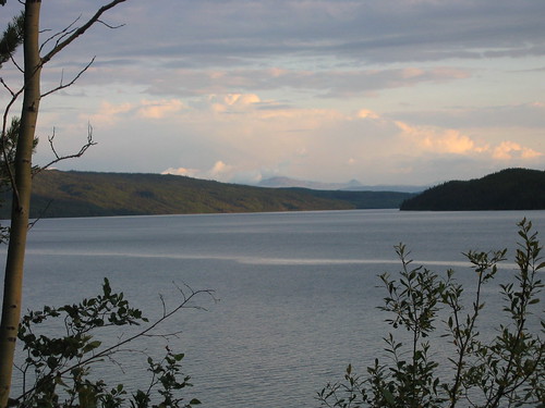
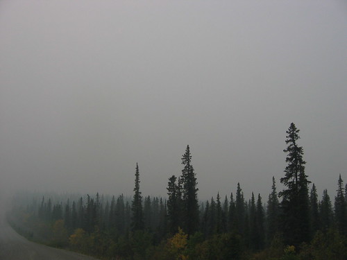
As we passed onto the Top of the World Highway, we began to see the reason that the sky had been increasingly hazy in the prior week. The smoke was so thick in places that we couldn’t see more than 50 feet in front of us. A man at a gas station assured us that the fires were well off the road—indeed, the two biggest were burning a few hundred miles north. Here, you can see what the smoke did to an otherwise beautiful summer day (see especially the lower left corner).
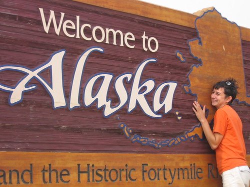
And here I am, very happy to have passed without incident back into the United States (our 8th border crossing). We’re at—essentially—the northernmost point of the trip. The Highway is incredible here as well, cut out of the flanks of low mountains of endless tundra. (no photos of it, though—the smoke was too thick)
Within a few miles, we entered the town of Jack Wade, which had eroded to this:
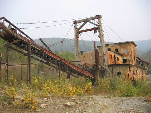
That was the entire town. In reality, it’s just an old gold dredge, abandoned and left for the tour buses that clambor over the pass from Dawson City. I think the local maps leave the dot there for a chuckle, but maybe Alaskans have a kind of memororial instinct I don’t credit them for.
In any case, within two hours we were in Chicken, which at least has a semi-permanent population of about 12, twice-weekly mail service, and a bar.
To be continued…
We left Jasper, Alberta, and headed for the Cassiar Highway. It’s a narrow road crowded with trees (and remnants of trees from 50 years of forest fires that have been allowed to burn themselves out), without benefit of painted lines or pavement for many of its 750 kilometres. In the two days we spent driving on the road, we estimate we saw only 50 cars. There are no towns to speak of, just gas stations every few hundred kilometers where you might find a Dove Ice Cream Bar and cap guns, but little or nothing practical such as canned foods or soap. The emptiness, the trees, the practicalities, the ill-fitting designation of “highway”—these all contributed to make it our favorite road so far. Our first night camping, we located a spot on the Dease River that local fisherman had rigged to camping perfection: a picnic table, an outhouse (which was a little too ripe to use), a view of the sun setting over a wide bend in the icy blue river.
Despite being 20 yards from the highway, there was no traffic to disarm our sleep.
On the second day, as we noticed the sun becoming more obscure, we drove for 12 hours continuing up the Cassiar into Whitehorse and the Yukon. I expected some sort of urban, wood-cabin oasis (with 20,000 people, Whitehorse is a metropolis by local standards) , but we found an entire city built around the concept of prefabulousness. Nearly every building we saw looked as if a truck had carried it in, one or two pieces at a time, from the highway. We provisioned, anticipating nearly two weeks without grocery stores before arriving in Anchorage, and then decided to move right along and skip the beers we’d been planning on having. We headed up the Klondike Highway, which would take us north of the Alcan (the major route into Alaska) and drop us into Alaska near Chicken. That night, we drove until dusk (nearly 10pm this far north) and found a gravel turnabout in which to camp. As we came around the bend, we saw that our empty site was in fact inhabited by seven people resembling gypsies—clothes strewn about on willow branches, a huddled group around a stove and a fire, three tents draped with more clothes … John and I looked at each other, shrugging simultaneously. He jumped out of the truck and asked if they’d mind if we pitched a tent in their camp, which was greeted with warm assent. Upon closer examination we found that the clothes were of the REI variety, and the tents, though worn, tended for with care. The stove turned out to be a pressure cooker in which they were making chocolate cake. And the metal dinosaurs poking out from under piles of drying clothes? Bicycles! Our gypsies turned out to be a motley group of mostly Canadian cyclists, who were just about to complete a trek from Patagonia (the tip of South America) to Inuvik (the most northern point accessible by road in Canada). The most veteran among them had been riding for 18 months, making a documentary along the way, which they hoped to turn into a curriculum for middle and high schoolers. We stayed up talking for a few hours, as twilight slowly dimmed into darkness, eating chocolate cake and drinking rosehip and alfalfa tea. What they were doing put our own minor complaints about sore muscles, tent pitching, and homesickness on permanent hold . A few hours drive north (or three-days ride) they would split off our route, taking the Dempster Highway to Inuvik, while we would take the Top of the World Highway across the northernmost U.S. border crossing into Alaska. The next day when we reached this crossroads, we stopped and poured off half of our bottle of scotch into a small plastic container and hid it in a cairn with a note we hoped they would see. We thought they deserved it a touch more than we did - celebratory drink at the capstone of a months-long endeavor more hardcore than anything we could imagine. We're hopeful they found it.
As we passed onto the Top of the World Highway, we began to see the reason that the sky had been increasingly hazy in the prior week. The smoke was so thick in places that we couldn’t see more than 50 feet in front of us. A man at a gas station assured us that the fires were well off the road—indeed, the two biggest were burning a few hundred miles north. Here, you can see what the smoke did to an otherwise beautiful summer day (see especially the lower left corner).
And here I am, very happy to have passed without incident back into the United States (our 8th border crossing). We’re at—essentially—the northernmost point of the trip. The Highway is incredible here as well, cut out of the flanks of low mountains of endless tundra. (no photos of it, though—the smoke was too thick)
Within a few miles, we entered the town of Jack Wade, which had eroded to this:
That was the entire town. In reality, it’s just an old gold dredge, abandoned and left for the tour buses that clambor over the pass from Dawson City. I think the local maps leave the dot there for a chuckle, but maybe Alaskans have a kind of memororial instinct I don’t credit them for.
In any case, within two hours we were in Chicken, which at least has a semi-permanent population of about 12, twice-weekly mail service, and a bar.
To be continued…

0 Comments:
Post a Comment
<< Home