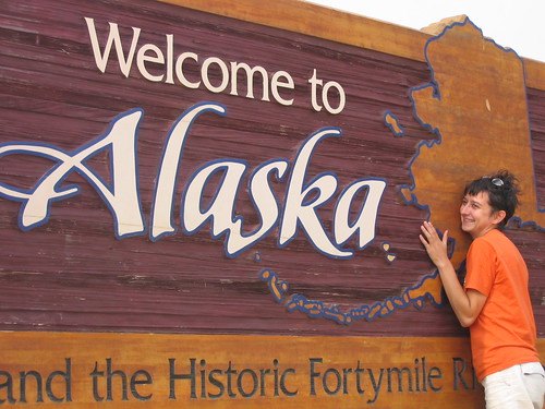
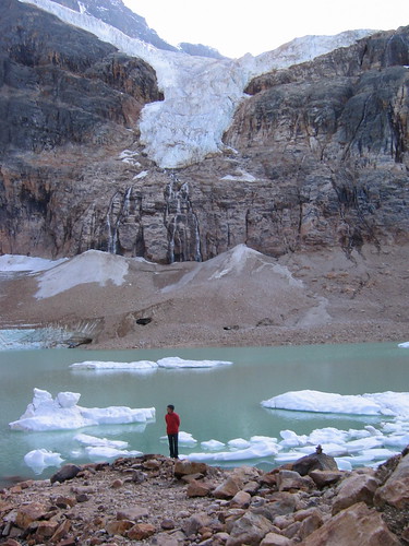
Monday, August 29, 2005

Alaksa, Part !!

Update: The battery on my computer has expired, so we golden as long as we can plug in. A new one is being shipped to Spokane for me, but until then, no pre-writing on the road. Posts may thus become a bit shorter in the short term. Apologies, and god love waranties. And now...

Part !!

Should such a thing exist, an epic limerick would be Chicken’s anthem. Beautiful, downtown Chicken, Alaska, consists of a bar, a liquor store (just a window out the bar), a gift shop, the Chicken Café, the chicken coop, and the Chicken Poop (a wheelchair accessible triumvirate of outhouses). But much like the Cassiar Highway was not entirely a highway, “downtown” Chicken doesn’t much resemble any sort of downtown—in part because there’s no “town” for it to be down of. The only other thing in Chicken is an RV park, a gas station, and an airstrip where the mail is flown in and out twice a week. About 20 or 30 people live there in the summer, running these various businesses. The population drops to about zero (give or take) in the winter, when the highways into town are closed and you’re sealed in for eight months.

Downtown is owned and run by Sue, at some point from Pennsylvania. She’s a loud, obnoxious, talkative, braggart of a woman, who is in the process of getting a messy divorce from Gary the Pilot, but is dating Steve the Rich Guy. She shot a huge “boo” (caribou) from 1,000 feet, right between the eyes. Her son was badly burned at the age of 12, or maybe it was 14, and airlifted to Seattle. Her bartender is named Randy, and was in Fairbanks when we arrived, so she was parked behind the counter covered in graffiti etchings—this is how we know so much about Sue, although she’d probably tell you all of it within any hourlong conversation. Especially the part about the caribou. She wakes up at 5 AM and makes trays of cookies, pies, and muffins to feed the tour busses full of people that stop in during the summer. That’s why the Chicken Poop is wheelchair accessible—to appease the tour companies who bring in a huge chunk of revenue to Sue’s business, which only runs four months of the year.

Also living in Chicken were Gary and Matt. Matt is our age, and decided to hop on a plane to Alaska in May, never having been there before. He ended up working for Sue—the day we were there, he was line cook, bartender, kitchen hand, and dishwasher and worked from 7 AM to at least 11 PM when we went to bed. Gary was a Marine for 40 years, and is now something of a hippy. He lives in a school bus that he rigged up with a sauna, and has long grey hair and a thick beard. He was shot in the head in Vietnam and is trying to convince the government that he’s crazy (which, objectively, he kind of is). Apparently they keep telling him that loss of memory, insomnia (he sleeps two hours a night), and a change in his personality don’t have anything to do with being shot in the head. He says he’s almost got them convinced, though. Gary’s been in Alaska for five years, and loves it. He also works for Sue, doing almost the same things as Matt does, in addition to operating “the canon.” He’s sweet like a child is, but a little mischievous. His experience in the Marines taught him to love artillery fire in general, and gunpowder in particular. Once we’d been parked in the bar for about two hours, Gary mentioned a novel way to get a free drink. Take off your panties and pack them into the canon with about 7 packs of gunpowder. Aim, fire, and booze. The remnants of one of my favorite pairs of Betty-Boop polka-dotted undies are now stapled above the bar, along with about 400 other scraps, numerous men’s ballcaps, and thousands of notes, business cards, and dollar bills with people’s names and home places scrawled on them. Mine say: Hanna (D.C.) in thick black permanent marker.

In the Chicken Saloon, which was recommended to us by a friend who’d passed by two years prior, we parked ourselves at about 5pm, Alaska time (they have their own time zone up here). For a while, we were ignored as Sue and some folks from Wasilla (near Anchorage) chatted about divorce, hunting, and Captain Morgan. Drinking the local brew from the tap marked us as passers-through, “bourgie” tourists, east coasters out on a whim. Once we opened a tab though, and started in with the MGD, the locals opened up a bit. We made friends with another Gary and his wife (name unremembered)—two of the hardest drinking people I’ve ever met. Gary works construction on bridges and docks, and had worked winters in Prudoe Bay (the Alaska Pipeline’s northern terminus in the Arctic Circle), where it can get down to more than 100 degrees below zero. After a few rounds he brought out the best salmon dip I’d ever had (which he made from Alaskan red salmon he’d caught this summer), and a smoked terryaki salmon that tasted like an orgy of sweetness. They complained about the Lower 48ers, who brought their laws with them to the wilderness—primarily, seatbelt and gun laws. He and wifey were in Chicken hunting caribou before the season closed. He indicated he had many guns, she indicated that handguns were her personal favorite. He was incredulous when we told him that Washington, D.C. doesn’t have bears. “No? You gotta have some bears, somewhere. Can’t have no bears,” he said. It was hard to convince him that the nearest bears were in the zoo, and the second nearest were in Wyoming. The conversation degenerated as we continued drinking, mostly to talk of looooove. They were really in loooove. He used to “hate women and everything about em, until I met this firecracker here.” They (she especially) were really happy we were in loooove too. She loooooved our looooove. We danced a drunk dance to the jukebox (the numbers don’t correspond to the songs they say they do, it just plays whatever it wants – I think 237 got us Janis Joplin), and stumbled out.

The Chicken staff, enamoured of us now that our tab was good and deep, wouldn’t hear talk of pitching a tent in the parking lot or sleeping in the truck. Nope, they had a little cabin, empty for the night, and we would stay there. A little single bed, but Gary thought the two of us were skinny enough to fit comfortably on it. The other cabin, with a wood stove, was airing out from a previous drinker’s expurgations.

We slept like babies, our first night in a bed since Hamilton, Montana. Sue woke us up at dawn, yelling at Gary for forgetting to cap the generator, and was yelling at him again at breakfast for burning the cookies (“I won’t catch that hell again,” he said when she left the room). I think there might be something to memory loss and a gunshot to the back of the head, but hey, I’m not the VA.

IMG_1656

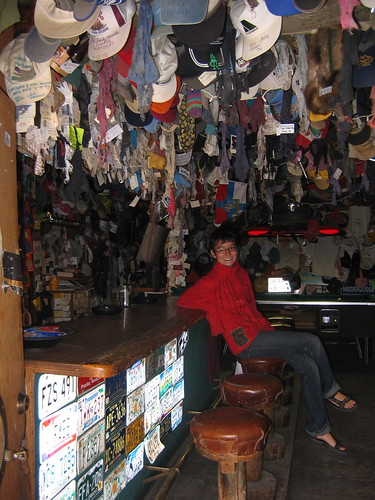
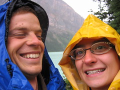
Hanna in the Chicken Saloon. You can see I'm not the only one to dismember her panties. We have action shots of the canon firing, but they're a bit dark and a bit personal. By request only.

Next up: the Denali Highway; and then: Denali National Park; and then: Anchorage!

Oh, Misery

You should be reading Alaska, Part !! right now, but due to an unfortunate incidenct with a dog's tail and a glass of water, my Mac isn't turning on. We're taking the little dear to be fixed (although with turnaround times at 7 days, and our plan to be on a ferry 7 days from now, we're not sure how well it will work out). In the meantime, we'll try to post from other computers. Unfortunately, there were two posts pre-written that we were going to put up this morning -- about our experiences in Chicken and Denali National Park. We'll just have to stick em up when we get the computer running again. Sorry, guys. We continue to be lame.

In travel news: we're leaving Anchorage today, I think, and heading to the Kenai Peninsula. Then we'll sweep back through Anchor Town for a climb with a friend of ours (on balet!), and then head east toward the Wrangell St. Elias National Park (the largest in Alaska, supposedly even wilder than Denali). Then back down to BC via the Cassiar, to get on a ferry from Prince Rupert to Port Hardy (on Vancouver Island). From there, we're heading to the Olympic Peninsula in Washington State, to camp on the Pacific Coast (September 11-13). Then, hopefully, to Seattle for a few days, and finally to Spokane to visit with my family (hopefully, my mom will be flying out for a week of visiting as well) on or around September 17. That's the general schedule. Let us know if you're in any of these areas over the next few weeks.

Sunday, August 28, 2005

Alaska, Part !

We know it’s been a long while since the last post, but Alaska has found us both bereft of much internet access and quite exhausted when we’ve found it. Apologies, apologies. Here’s the story, or what we can muster of it.

We left Jasper, Alberta, and headed for the Cassiar Highway. It’s a narrow road crowded with trees (and remnants of trees from 50 years of forest fires that have been allowed to burn themselves out), without benefit of painted lines or pavement for many of its 750 kilometres. In the two days we spent driving on the road, we estimate we saw only 50 cars. There are no towns to speak of, just gas stations every few hundred kilometers where you might find a Dove Ice Cream Bar and cap guns, but little or nothing practical such as canned foods or soap. The emptiness, the trees, the practicalities, the ill-fitting designation of “highway”—these all contributed to make it our favorite road so far. Our first night camping, we located a spot on the Dease River that local fisherman had rigged to camping perfection: a picnic table, an outhouse (which was a little too ripe to use), a view of the sun setting over a wide bend in the icy blue river.

IMG_1634

Despite being 20 yards from the highway, there was no traffic to disarm our sleep.

On the second day, as we noticed the sun becoming more obscure, we drove for 12 hours continuing up the Cassiar into Whitehorse and the Yukon. I expected some sort of urban, wood-cabin oasis (with 20,000 people, Whitehorse is a metropolis by local standards) , but we found an entire city built around the concept of prefabulousness. Nearly every building we saw looked as if a truck had carried it in, one or two pieces at a time, from the highway. We provisioned, anticipating nearly two weeks without grocery stores before arriving in Anchorage, and then decided to move right along and skip the beers we’d been planning on having. We headed up the Klondike Highway, which would take us north of the Alcan (the major route into Alaska) and drop us into Alaska near Chicken. That night, we drove until dusk (nearly 10pm this far north) and found a gravel turnabout in which to camp. As we came around the bend, we saw that our empty site was in fact inhabited by seven people resembling gypsies—clothes strewn about on willow branches, a huddled group around a stove and a fire, three tents draped with more clothes … John and I looked at each other, shrugging simultaneously. He jumped out of the truck and asked if they’d mind if we pitched a tent in their camp, which was greeted with warm assent. Upon closer examination we found that the clothes were of the REI variety, and the tents, though worn, tended for with care. The stove turned out to be a pressure cooker in which they were making chocolate cake. And the metal dinosaurs poking out from under piles of drying clothes? Bicycles! Our gypsies turned out to be a motley group of mostly Canadian cyclists, who were just about to complete a trek from Patagonia (the tip of South America) to Inuvik (the most northern point accessible by road in Canada). The most veteran among them had been riding for 18 months, making a documentary along the way, which they hoped to turn into a curriculum for middle and high schoolers. We stayed up talking for a few hours, as twilight slowly dimmed into darkness, eating chocolate cake and drinking rosehip and alfalfa tea. What they were doing put our own minor complaints about sore muscles, tent pitching, and homesickness on permanent hold . A few hours drive north (or three-days ride) they would split off our route, taking the Dempster Highway to Inuvik, while we would take the Top of the World Highway across the northernmost U.S. border crossing into Alaska. The next day when we reached this crossroads, we stopped and poured off half of our bottle of scotch into a small plastic container and hid it in a cairn with a note we hoped they would see. We thought they deserved it a touch more than we did - celebratory drink at the capstone of a months-long endeavor more hardcore than anything we could imagine. We're hopeful they found it.

As we passed onto the Top of the World Highway, we began to see the reason that the sky had been increasingly hazy in the prior week. The smoke was so thick in places that we couldn’t see more than 50 feet in front of us. A man at a gas station assured us that the fires were well off the road—indeed, the two biggest were burning a few hundred miles north. Here, you can see what the smoke did to an otherwise beautiful summer day (see especially the lower left corner).

IMG_1640

And here I am, very happy to have passed without incident back into the United States (our 8th border crossing). We’re at—essentially—the northernmost point of the trip. The Highway is incredible here as well, cut out of the flanks of low mountains of endless tundra. (no photos of it, though—the smoke was too thick)

IMG_1642

Within a few miles, we entered the town of Jack Wade, which had eroded to this:

IMG_1646

That was the entire town. In reality, it’s just an old gold dredge, abandoned and left for the tour buses that clambor over the pass from Dawson City. I think the local maps leave the dot there for a chuckle, but maybe Alaskans have a kind of memororial instinct I don’t credit them for.

In any case, within two hours we were in Chicken, which at least has a semi-permanent population of about 12, twice-weekly mail service, and a bar.

To be continued…

Saturday, August 13, 2005

Rock, Rock On in the Rockies

So here we are in the Canadian Rockies. It’s relatively difficult to describe either the scale or the magnificence of things here. Some facts help, but only a little. We’ve been staying in two national parks that follow the Continental Divide. They include some the biggest mountains in North America, and they’re packed together like Easter eggs in a basket. We camped the first two nights on Mosquito Creek, setting up our tent about two feet from where the glacier-fed water touched the bank. It made a damp roar that effectively isolated us from our neighbors—no doors slamming or dogs barking. It was as near to a perfect campsite as we’ve had.

It was also cold. Cold and rainy, actually. The day we arrived, we opted for a quick hike up one of the main tourist paths, from Lake Louise (a milky green lake, ladled into a tight valley between massive glaciated peaks) to Lake Agnes, where a teahouse has stood for about 100 years. By the time we reached the top, it was hailing and the wind was chirping at us get off its mountain. We popped into the chilly teahouse and drank a small pot of yerba mate and were served an ungenerous bowl of tomato soup. Still sopping and shivering, we took the chance during a break in the rain to hop down the mountain. We there rediscovered what most five-year-olds know: that “The Ants Go Marching” is an excellent song to pass the time on a cold hike (and that nothing rhymes with “seven” but “heaven”). We stopped at a Laundromat to dry our pants and long underwear and then cuddled into bed, bellies full of split pea soup and baked beans. (Our bed, for those curious to know, is a masterpiece of comfort: two air-filled ground pads, covered with a thick warm lambskin rug, covered with a soft linen sheet; we nestle between this and an unzipped sleeping bag [it reflects body heat] with a down comforter over everything, and two fluffy pillows make cherries on top. It takes about half an hour to set up the tent and bed, and the same to pack up in the morning, but clearly worth the effort.)

Day two we went on a spectacular hike to the Bow Glacier Falls. (Another aside: the use of adjectives like “magnificent” and “spectacular” may seem gratuitous, but try to keep in mind the full weight of their meaning. Things here are indeed worthy of such incredible appendations.)

John’s turn:

As you can see from the photos that are being posted with this post, Hanna is not exaggerating. I have never been to this part of the continent and over the past 5 days or so I don’t think that I’ve stopped grabbing Hanna’s attention away from reading or otherwise passing time in the passenger seat, worried that only I would see that magnificent view. It wouldn’t quite be real if she didn’t see it either. Each turn of a corner or pass down a hill reveals a new awe-striking wonder of the world. I will mostly let the pictures tell the story for now, but imagine that over the last four days we have: hiked and camped along countless glacier-fed bodies of water, summitted a 7,000-foot peak to overlook Jasper’s largest lake on one side and a valley with snow-capped mountains emerging from the depths on the other; washed our faces in a lake being fed by the melts of three glaciers (all within sight); watched snow and ice fall from a massive hanging glacier and thunderously fall down the mountain; seen bears, bighorn sheep, mountain goats, coyotes, an eagle, and today we caught a rare glimpse of a woodland caribou (there are only 100 in Jasper National Park). This is the quick and dirty rundown, mostly because I can think of no descriptors that would adequately capture the world that we are seeing up here. I am enthused with each moment and exhausted by my own enthusiasm all at the same time.

Hanna again:

I sort of pooped out with describing Bow Glacier up there, but it’s getting late we still have to go grocery shopping and drive back to camp to make dinner and watch the sun set over the icy blue of the North Saskatchewan River (our current campground is 20m from there). We head out tomorrow for the Yukon and hope to be in Alaska within a week. Not sure how the internet access will fare up there, but we’ll do our best. For real this time: let’s all go to the Canadian Rockies.

Photos:

IMG_1557

Hiking in a hail storm at Lake Louise.

IMG_1536

Hanna is amazed by wildlife in Glacier National Park.

IMG_1574

John poses for his action shot: hiking over a boulder bridge on the way to Bow Glacier Falls.

IMG_1578

This is the view from the waterfall coming off of Bow Glacier. We hiked through this canyon, following the river, all the way from the lake you see in the background (Bow Lake). We scrambled about halfway up the 800-ft. falls for this photo.

IMG_1605

Hanna in front of Cavell Pond, at the base of Edith Cavell Mountain in Jasper. Just out of view, on the left rim of the pond, is a glacier that provides the icebergs you see floating in the background. Above Hanna is the Angel Glacier (a "hanging" glacier)--this is where we saw (and heard) ice cracking off the glacier and tumbling down the mountainside (it sounds a bit like a canon being shot).

IMG_1616

John on the summit of Bald Mountain, with Maligne Lake behind and below us (we hiked from a parking lot at the left tip of the lake). We call the summit "Little Europe" because there were about 12 different groups of mixed-bag Europeans up there. Mountain tops are friendly places, too: some girl from California gave us her phone number in case we need a place to stay in Santa Rosa.

“Your answer to this question will determine the future of your trip.”

Although we fully anticipated that we’d be stopped at customs on at least one of our forays across the Canada/US border (there have been seven now), neither of us really expected to be so thoroughly harassed. At an early venture—crossing in small-town Maine—the border guard took one look at us, declared that our truck was a customs officer’s nightmare, and waived us through with a smile and a nod. Not so two days ago. We were crossing through the northeast tip of Glacier National Park into Alberta, and the young guy in the customs booth was not amused with our very out of state plates, unkempt hair (four days since last shower), and impenetrable conveyance. He passed us along to two ladies, who took over searching the car and were determined to find—as they put it—“it.” “It” was “dope,” as they eventually let us know, and they indicated (again and again) that they’d tear apart the car until “it” had been found. (Funny, because none of them could have been much older than we are, and whom of our generation calls it dope?) After over an hour, they pretty well had torn the car apart—looking in every pocket of every bag, through every pill container in our first aid kit, and even climbing up on top of the car to rip apart the cargo bag. We remained—per their mandate—at the front of the car, shivering. They finally conceded that, as we had persisted in telling them, we did not have any “dope”—and passed us along to the immigration guy. He didn’t seem to be taken with the idea that we were jobless and traveling for six months, and he didn’t hesitate to make this clear. John and I both reached a low point, I think, and began to feel causeless guilt about being young and free and jobless and all of the other things these customs officers were not. This severe, dark haired man asked us about everything we’d been labouring not to think about—our most recent jobs and incomes, our bank accounts, and how much cash we had on us (and then made us go get it to prove we weren’t lying). He verified everything (including our nonexistent criminal records), then brought us in for the culmination of the interview. Here he delivered the titular question, in as weighty a tone as the best of western lawman: “Your answer to this question will determine the future of your trip.”[Pause for effect; look piercingly into our lying, thieving, whore-mongering faces.] “Do you have any dope in that truck?” Well, no sir. Like we’ve been saying. Shucks and goddamn, no. Then he paused, just to be a real jerk, and drummed his fingers on the desk, and tapped his pen, and generally tried to heighten the effect, and finally, after a very long 30 seconds, he put pen to paper and wrote: Accepted.

Thus, we’re in Alberta. And thank god for that, because this must be the most beautiful place in the world.

But first, our second adventure of the day. After a beautiful drive through southwestern Alberta, winding through the Kennakasis Valley with giants of mountains kneeling on either side, we arrived in Canmore, Alberta. This is a sleepy-ish mountain town, still relatively untouched by the tourism bug that plagues neighboring Banff. We decided to shack up in Canmore for the night because the entrance fees to Banff are outrageous and all we wanted was to cook dinner and sleep. The very informed girl at the information center guided us to a municipal campground just around the corner. A municipal campground—what a lovely idea. We jumped in the rig and hit the gas and turned the corner and what the hell? We could tell it was a bit strange from the get go. First, it was right off the highway, with traffic roaring by and no privacy. You’d think (or I would) that a municipal campground would be set up to show off the better part of a city or it’s scenery, so we were skeptical from the first. Second, it was split into two parts—overnight camping on an almost treeless grassy area with no specified sites (“just camp anywhere you like”), and “long-term” camping located across the parking lot in completely secluded sites in a mess of a little forest. We thought we would check these sheltered sites out (just in case we could score one), and we found a whole subculture just out of view. One site had a clock and dartboard hung up on a tree outside the tent. Others had motherloads of laundry hanging from criss-crossed lines. There were probably 50 sites and we only saw one empty, and they all looked lived in. There were kids our age everywhere—ranging from the mountain men types to the granola set—but we decided it looked like fun and might be a good opportunity to meet people. Meet people we did—at a group campfire, in the kitchen shelter, in the bathrooms. As we talked to more people the outline of the place began to take shape. About 90% of the long-term campers are from Quebec and were there for most of the summer months. Some of them go west for part of the summer to pick apples or other fruit, earn a ton of bank, and then retire to this little haven just outside the Rockies for the rest of the summer. A few of the guys we met were tradesmen, working construction jobs that paid better out here in the summer (multi-million dollar homes are going up everywhere), and then headed home to Winnipeg or Edmonton or Saskatoon in the fall. No one looked older than 30, and I’m sure some were under 20. Not surprisingly, it was run like a commune. They made money off the overnighters ($15/night vs. $240/month—although I have to say, even the reduced monthly rate seems like a lot for no roof or heat, etc.), and had rules set up to govern the conduct of the residents (e.g., no alcohol at the fire pit, non-registered guests leave by 11, etc.) so it all doesn’t go completely haywire. I think the strangest thing was that the city bankrolled the place, but it was pretty amazing to see that it existed—I can’t imagine a city in the U.S. that would do the same for a bunch of vagabonding kids.

Saturday, August 06, 2005

Q. What’s the best part about farting in Yellowstone?

A. You can blame it on the geyser!

You can probably infer a few things from this joke we made up. First, Yellowstone smells like rotting eggs. Second, we’ve been together in car and tent enough now that bodily emissions are often at the forefront of our conversations. (I really have my grandfather to thank for this tendency, who nobly taught all the cousins to belch on command, and provided us with the “Vibrato Scale” with which we could reliably rate our flatulence. I don’t know whom John has to thank.) Third, we’ve started making up jokes, which is traditionally the province of truckers and traveling salesmen. I’m not sure what it says about us, exactly, except that we’ve spent a lot of time in the car and that our ability to distinguish between good jokes and farting jokes is on the decline. In case you’re not sure: That joke is hilarious.

Brinkman is doing just fine. We haven’t quite figured why he keeps getting out of balance, but it might have something to do with the fact that he’s 16 years old—an adolescent and an old man at the same time. He was in boyish spirits the other night, however, and managed to save us from being trapped in Yellowstone. The thrilling adventure follows.

The Thrilling Adventure (and scenic details for the adventure-skittish reader):
We set up camp in Shoshone National Forest, about 40 miles east of Yellowstone. The camp sites are quieter, emptier, and more scenic there – we were right on the Shoshone River, across from a sheer break of rock tumbling up out of view. We ate raspberry pancakes the following morning, and set out for the east entrance to the park, which we discover is under construction – hour-long waits up a steep, one-lane, dirt road in the nation’s busiest National Park. We muscle through, and emerge onto the east rim of the caldera. Yellowstone was a vague place in both our minds, full of bears and geysers and not much else. In fact—a fact neither of us realized—the park is an old volcano that simply collapsed. The caldera is formed by the collapsed basin, which was then filled in by immense lava flows, creating rolling hills and meadows in the midst of a huge lodgepole pine forest that burned in fires in 1988. In the middle of it all is the largest alpine lake in the world—stretching 480 feet down toward the heart of the mountain and averaging 40 degrees cold in its depths. In various little geyser basins, however, the volcano retches up its heat in the form of hotsprings, mudpots, fumaroles, and the big daddy geysers, whose microbes oxidize iron and sulfer to create chemical-looking spits of color in the desolate grounds (the heat kills almost everything else alive). It’s one of the most active geothermal areas in the world. The landscape is amazing in it’s variety and extremity.

The flip side is that it feels like one of those safari parks you find outside of struggling tourist towns: BearWorld, or Wild Walks, or I’m So Captive. The difference, in theory, is that wildlife really is wild in Yellowstone, but you almost wouldn’t know it. We thought we saw a bear, but it turned out to be a buffalo swimming across the river and walking into traffic, entirely unconcerned with the herd of metal beasts stopped in its wake (wildlife jams we called them, where the cars pile on top of each other to see the biggest animal they can). There’s something like 200 miles of road in Yellowstone, as well as gas stations, an Auto/RV repair shop, lodges and inns, campgrounds, general stores, souvenir shops, amphitheaters, and just immense numbers of people. We had the constant sensation of moving through it passively, despite the severity of the wilderness just off the road.

Anyway, then we thought we saw a wolf (it was a pronghorn). Then we thought we’d see Old Faithful.

At ten to six, we arrived to get a front row seat for the show on the giant platform built around the little geyser that could. By 6:40—no geothermal expulsion in sight—we realized we had to leave, and fast, to get out of the park by 8:00 when the east road was closing for overnight construction. We were 65 miles away, and at a speed limit of 45 mph, we were not at all assured of making it. To emphasize the real hazard this posed to us, understand that there was absolutely nowhere we could sleep in the park, and the nearest other exit would put us out about 250 miles from our tent and everything that could keep us warm for the night. We had to average almost 60mph up hills that Brinkman could only climb at 35mph, around windy park roads, contending with slower-moving RVs and wildlife jams. John turned to me and said, “Hon, are you prepared not to make it out of the park?” To which I replied, “Hell no. Drive.” And he did. A nail-biting hour and twenty minutes, the whole of it spent on the literal edge of our seats, forming motherload knots in our backs. Brinkman was in perfect form, roaring up the pass, shooting past RVs, gliding down hills well beyond his usual top speed with barely a shimmy. But at 7:58, one mile from the road closure, a police car was turned out in the road and we were crushed. We slowed down to plead with her to let us out anyway, and she said such glorious words we almost kissed her hands: “Hurry up.” We were the last ones out of the park, and missed the gate closure by about 1.5 minutes. We got out of the car and gave each other the hugest, most bringin-it-back high five the 21st century has ever seen.

Postscript: The next day, on a hike back in the park, we finally got to see Old Faithful blow it’s load from on top of a fire-stricken mountain. From four miles over and a half-mile up, it looked like a little kettle screaming. Yellowstone is a furious place, strangely subdued. Despite the fact that it was so trafficked and so packaged, it managed to surprise and delight us every time we caught a glimpse of it’s tantrums and fits of wilderness. Let's all go to Yellowstone.

Tuesday, August 02, 2005

Technical Cowboys

For real, that's the name of the service station currently balancing our wheels. The guys all wear patches that say "Technical Cowboy." We're in Cody, WY.

Last night we stayed in the Bighorn National Forest, on a wide-open resevoir at about 9,000 ft, overlooking snow-capped Cloud Mountain, checking in at 13,000 ft. We were the only people there -- an eerie feeling after weeks of RV parks and National Parks, and parking lots.

We kicked the 4WD into high gear to get up the Forest Service roads (for the first time), and climbed through at about 10mph (destroying the wheel balance in the process). It was tons of fun, and we finally felt like we were putting Brinky through a proper workout.

We have to go collect the truck, so this is brief. Hello to all.